A Late-Summer Walk for Noticing a Hillside
A late-summer hillside walk helps you spot contrasts in slope, shade and vegetation, then record them clearly without mistaking appearance for explanation.
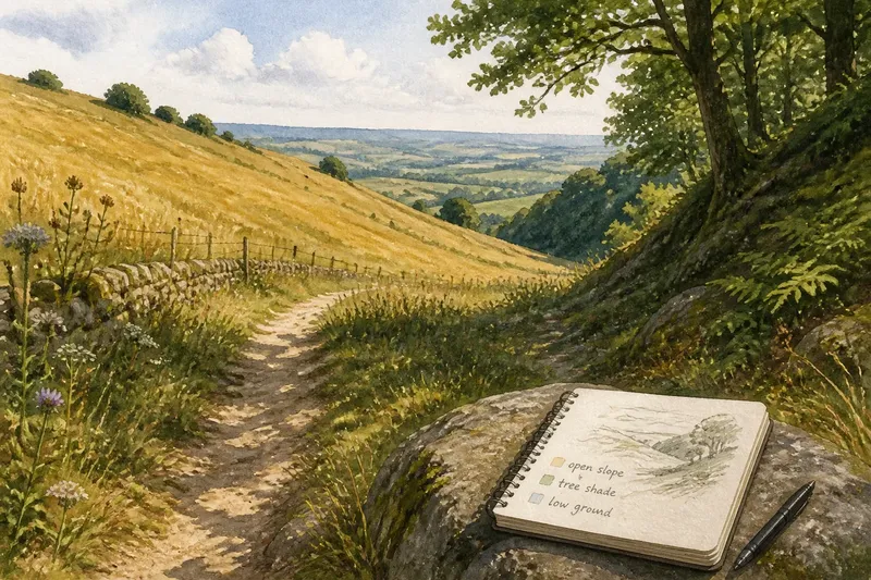
What changes as you walk across a familiar hillside, and how can you record it without guessing at the cause? A late-summer hillside walk makes contrasts in slope, shade and vegetation easier to notice. Choose a familiar path with an open stretch and a shaded hollow, then compare what is visible from safe stopping places.
Late summer can bring flowering plants, seed heads and patches that have dried back. Keep your attention on the ground beside the path, the slope ahead and the skyline. A pocket notebook or phone note is enough; the aim is a clear account of the terrain, not a formal survey.
Break a broad view into smaller parts
A hillside can look uniform when a path crosses it from the side. Near ground may hide a hollow, while distant plants blend into one colour. Divide the view into nearby sections and compare an open shoulder with a shaded stretch, if the route offers both.
Notice where the slope steepens, flattens or turns. At a safe stopping place, look back along the route: a change in direction may make the shape easier to read. Stay on the path rather than seeking a better angle on loose or steep ground.
Separate shade from the pattern of vegetation
Record what casts the shade: a tree canopy, a bank or the hillside itself. Note whether the area is shaded at that moment or lies on a slope that receives less direct sun. The boundary may shift during the day, so treat it as a feature of your visit rather than a fixed line.
Compare plants at the edge of the shade and a short distance beyond it. Describe whether the change is gradual or sharp, and whether the plants are low, tall, scattered, flowering, seeding or still leafy. Shade and vegetation may coincide without one fully accounting for the other.
Describe plants and land use in plain terms
Late-summer vegetation can look different from one patch to the next for several reasons. Instead of relying on broad labels such as “dry slope” or uncertain species names, note observable details: short grass beside taller seed heads, ferns under trees, bare soil, fallen leaves or shrubs along a bank.
Check whether a visible boundary offers useful context. A fence, path edge or recently cut strip may separate ground that is managed differently. Record the boundary and the plant contrast; avoid extending what you see there into a claim about the whole hillside.
Read the shape of the ground from the path
Perspective can disguise a slope. A path that looks level may cross rising ground, and a shallow dip may become clearer when you see the land on either side. Look for rounded shoulders, small shelves and hollows, and compare the path with visible landmarks such as fence lines or tree trunks.
Make a rough sketch if it helps you remember where features sit in relation to one another. Mark “open slope”, “tree shade” and “low ground” rather than trying to draw a precise map. This is not worth turning into a detailed survey: estimating angles by eye or naming every plant can distract from the larger pattern.
Use dry patches as observations, not climate verdicts
A pale or bare patch in late summer may catch your eye, but its appearance alone cannot tell you why it is there. Look around its edges: does it follow a path, exposed rock, a slope change, a line of trees or a land-use boundary? Note whether plants grow in cracks or small pockets.
Compare it with a nearby part of the hillside, but remember that the two places may differ in several ways. If you return in another season, record what has changed and where. A later visit adds a fresh observation; it does not, by itself, identify the cause.
Make the route’s limits part of your notes
A contour path may show the hillside from the side without revealing how it changes uphill. A climbing route may expose changes in height but offer few chances to compare opposite-facing slopes. Neither route is a failed walk; each gives you a different view.
Use an existing bend or opening for a second safe viewpoint if one is available. If not, make a smaller comparison from the path and note what you could not see. Do not cross private land, climb barriers or leave a maintained path to complete an observation.
Say you usually follow a broad track below a wooded ridge. On this walk, you stop at an existing bend and see a shaded bank, a sunlit shoulder and short grass beside the track. You sketch their positions and describe the plants. Your resulting note identifies where the contrasts occur, while leaving their causes open.
What should you do when observations conflict?
What if a shaded patch looks drier than an open slope?
Record both features, then look for visible differences such as bare soil, rock or a path edge. Keep the description specific instead of treating shade as an explanation for surface condition.
What if you cannot identify the plants?
Describe their height, leafiness, flowering and spacing without guessing at names. If identification matters, check a reliable local field guide or ask a knowledgeable local organisation later.
What if the hillside looks different on your next visit?
Note the season, visible weather and places you compared, then describe the difference. Keep the earlier and later observations distinct rather than deciding from two visits what caused the change.
What if there is no safe viewpoint?
Make a smaller comparison from a safe place on the path, or leave it for another walk. A useful note can state that the route did not provide a view of a particular slope.
Keep a short record you can use later
Write down the location in ordinary terms, such as “north side of the track” or “below the tree line”. For each feature, record what you saw and the decision that follows if the observation is unclear:
- Check whether the ground rises, falls, flattens or forms a hollow; if its shape is clear, sketch it, then compare with the next stretch, and if not, note that the path hid the contour instead of estimating it.
- Check what casts the shade; if it is a tree canopy, bank or hillside, record that feature, and if the source is unclear, describe where the dark patch lies without assigning a source.
- Check plant height and spacing; if the contrast is visible, write “short grass beside scattered tall seed heads”, and if it is not, record the vegetation as mixed rather than naming species.
- Check the patch’s edge for a path, fence, tree line or exposed rock; if one aligns with the change, mark both in your sketch, and if none does, describe the edge without inventing a boundary.
- Check whether bare soil is continuous or broken by plants; if plants grow in cracks or pockets, note those locations, and if the surface is hard to see, leave its condition unrecorded.
- Check whether the route gives a safe view across the slope; if it does, compare the visible patches from that spot, and if it does not, stay on the path and write down what remains out of view.
These notes keep the hillside’s shape and visible contrasts in view without asking one walk to settle every explanation. On a late-summer hillside walk, a sketch, a few precise descriptions and an honest note about the route’s limits are enough to make a later comparison more useful.