The Straight-Line Map Trap
The straight-line map trap can hide how roads and paths connect places. Compare direct distance with the route network to see why a journey bends.
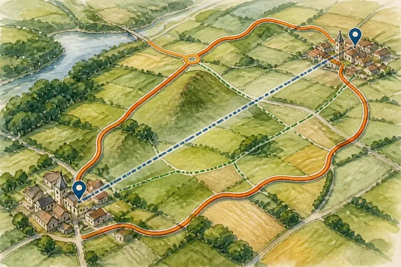
Why can two places look close on a map yet sit far apart in the route network? The straight-line map trap is the difference between distance across the page and the connected roads, paths or transport links that can take you there. A direct line measures separation; it does not show whether a usable route joins the two places.
To read that difference, compare the line with the network itself. Look for gaps, junctions and links between routes, then check whether each segment suits your mode of travel. The result is a clearer picture of how connected places are, without mistaking a short line for an easy journey.
Compare direct distance with network connections
Mark the start and destination on a map, then draw a light line between them. Treat it as a baseline. Next, trace the roads or paths that actually connect the points. Notice where the route follows a shared link, doubles back to a junction, or has to pass through another settlement.
This comparison is about connectivity, not just the length of the route. A place may be close in direct distance but poorly linked to its neighbour. Another place farther away may connect through a continuous road or rail service with fewer changes. Keep the mode clear: a walking path, a road for vehicles and a rail line form different networks.
At a regional scale, a map may omit minor streets, footpaths or local links. Zoom in around the start and destination to check whether the network reaches both. A line that appears to end near a town may stop short of the actual street or station you need.
Trace where the network joins and breaks
Follow each usable route from beginning to end. A continuous-looking sequence on a small map can conceal a missing link, a restricted path or a road that does not permit the mode you have in mind. Check symbols and labels, and use a more detailed map where the connection is unclear.
Pay attention to junctions. If several routes funnel through one point, that junction may be the practical link between areas. If a direct journey requires leaving one route, joining another, and then retracing part of the way, the network offers a weaker connection than the map’s close spacing suggests.
For public transport, trace the route through actual stops and interchange points rather than measuring between stations. For walking, confirm that mapped paths connect at their ends and are open to the public. A route planner can suggest a connection, but map coverage and travel settings affect what it displays.
Separate a long route from a weak connection
A long route is not always evidence of poor connectivity. It may be a direct, continuous link that covers more ground. Conversely, a short route may involve awkward transfers, disconnected streets or a path that is unavailable to your chosen mode.
Compare options by asking three questions: Does the route connect the exact places? Does it stay within the intended mode? Does it require a transfer or a change of network? These checks explain more than a single distance figure, particularly when comparing walking, driving and public transport.
What is not worth the effort is calculating an elaborate detour ratio from a rough line on a small-scale map. The arithmetic can look exact while the route information is incomplete. Finding the missing link or necessary transfer is usually more useful.
How can you compare map distance with a route?
Does a straight line show the route distance?
No. It shows direct separation between two points, not the length or continuity of roads, paths or public transport links. Trace the relevant network or use a route planner, then check the map details.
Why can a nearby place require a longer journey?
The route network may not connect the places directly, so the journey has to pass through a junction, interchange or another settlement. Compare the available links rather than assuming the nearest point on the map is the easiest to reach.
Should I compare walking and driving routes in the same way?
Compare each mode within its own network. A footpath may connect places that have no direct road link, while a vehicle route may need to use a different junction or crossing.
How can I tell if a mapped connection is usable?
Check the map’s route symbols, access labels and mode settings, then consult current information where access or service details may change. If the connection is unclear, choose a route with a confirmed link rather than relying on a line that only appears continuous.
Work through a route comparison
Say you are checking an invented journey between two villages shown close together on a regional map. The direct line appears to run straight between their centres, but the road map shows no connecting road. First, trace the roads from the starting village to the nearest junction. Next, follow the connected roads to the destination village and confirm that the final road reaches its centre. Then compare that vehicle route with the marked footpaths: if those join both villages directly, they provide a separate walking connection, not a shortcut for a car.
The resulting answer is specific: the villages are close in direct distance, but the vehicle network links them by a longer route through the junction, while the walking network offers a different connection. The trade-off is between following the confirmed road network and using a footpath only if walking is the intended mode and access is clear.
Check the route network before deciding
- Check the endpoints: If the mapped route reaches the exact start and destination, use it for comparison; if it stops nearby, zoom in and find the connecting street or path.
- Check continuity: If roads or paths join without a gap, trace that route; if a link is missing or uncertain, choose a confirmed connection or verify it on a detailed map.
- Check the travel mode: If every segment permits your intended mode, keep the route in consideration; if not, switch to a suitable network such as a public path or vehicle road.
- Check junctions and transfers: If a route needs a change, note where it occurs and compare another option; if the transfer is unclear, use a route with a clearly mapped interchange.
- Check the map scale: If the map shows only major routes, switch to a detailed view before deciding; if detail remains unavailable, avoid treating the apparent connection as confirmed.
- Check access information: If public access or service details are current and clear, use that connection; if they are uncertain, consult the relevant local authority or operator and select an alternative if needed.
The straight-line map trap is useful because it prompts a better question: how does the route network connect these places? Compare the direct line with the actual links, junctions and changes of mode. When the journey still seems awkward, the missing or indirect connection—not the map’s simple distance—is the detail to investigate.
For your next comparison, note the direct line, the usable route and any junction or transfer that changes the journey. That small record makes the difference between two places’ closeness and their practical connection much easier to see.